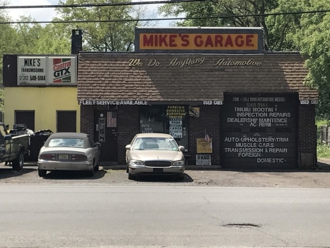
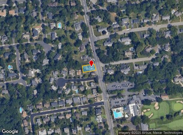
Property Record
265 Plainfield Rd, Edison, NJ 08820
NEARBY LISTINGS FOR SALE OR LEASE
Property Detail
265 Plainfield Rd
New York-Jersey City-White Plains, NY-NJ
Rod Top Heights
05-00593-01-00001-01
65X127
Servicestation
Middlesex
X
New Jersey
34023C0061F
1.1
2024
0.19 AC
2025
South Edison
001415
Northern New Jersey
DEMOGRAPHICS near 265 Plainfield Rd
1 Mile
3 Mile
5 Mile
2024 Total Population
11,065
120,828
328,854
2029 Population
11,007
119,903
326,750
Pop Growth 2024-2029
(0.52%)
(0.77%)
(0.64%)
Average Age
42
40
40
2024 Total Households
3,739
41,279
111,976
HH Growth 2024-2029
(0.59%)
(0.87%)
(0.69%)
Median Household Inc
$166,395
$123,996
$108,172
Avg Household Size
2.90
2.80
2.80
2024 Avg HH Vehicles
2.00
2.00
2.00
Median Home Value
$632,562
$458,398
$410,607
Median Year Built
1970
1971
1965
Nearby Places
Map Layers
Map Styles
 Street
 Aerial
- Restaurants
- Banks
- Shops
- Fitness
- Groceries
PUBLIC TRANSPORTATION
COMMUTER RAIL
Metuchen (Northeast Corridor Line - NJ Transit Commuter Rail (NJ Transit))
DRIVE
WALK
Distance
Metuchen (Northeast Corridor Line - NJ Transit Commuter Rail (NJ Transit))
4 min
1.6 mi
Metropark (Northeast Corridor Line - NJ Transit Commuter Rail (NJ Transit))
DRIVE
WALK
Distance
Metropark (Northeast Corridor Line - NJ Transit Commuter Rail (NJ Transit))
8 min
4.1 mi
AIRPORT
Newark Liberty International
DRIVE
WALK
Distance
Newark Liberty International
30 min
21.7 mi
Freight Ports
New York Container Terminal
DRIVE
WALK
Distance
New York Container Terminal
28 min
16.3 mi
SALE & LEASE HISTORY
LISTING DATE
SALE/LEASE

May 10, 2017
For Sale
Mar 05, 2018
For Sale
Nearby Properties
Address
Land Use
TOTAL SIZE
Lot Size
Zoning
Address
Land Use
TOTAL SIZE
Lot Size
Zoning
37.46 AC
EI
Address
Land Use
TOTAL SIZE
Lot Size
Zoning
65.84 AC
PB
Address
Land Use
TOTAL SIZE
Lot Size
Zoning
80,000 SF
23.37 AC
R50
Address
Land Use
TOTAL SIZE
Lot Size
Zoning
137.89 AC
RAA
Address
Land Use
TOTAL SIZE
Lot Size
Zoning
49.83 AC
LI
Address
Land Use
TOTAL SIZE
Lot Size
Zoning
55.57 AC
LI
Address
Land Use
TOTAL SIZE
Lot Size
Zoning
40.78 AC
RRRD
Address
Land Use
TOTAL SIZE
Lot Size
Zoning
96.22 AC
RA
Address
Land Use
TOTAL SIZE
Lot Size
Zoning
0.21 AC
LR
Address
Land Use
TOTAL SIZE
Lot Size
Zoning
35.98 AC
LI
Address
Land Use
TOTAL SIZE
Lot Size
Zoning
34.14 AC
LR
Address
Land Use
TOTAL SIZE
Lot Size
Zoning
3.18 AC
Address
Land Use
TOTAL SIZE
Lot Size
Zoning
10,173 SF
14.04 AC
OR
Address
Land Use
TOTAL SIZE
Lot Size
Zoning
23.32 AC
RBTH
Address
Land Use
TOTAL SIZE
Lot Size
Zoning
43.63 AC
MF
Address
Land Use
TOTAL SIZE
Lot Size
Zoning
5.83 AC
RO
Address
Land Use
TOTAL SIZE
Lot Size
Zoning
25 AC
LR
Address
Land Use
TOTAL SIZE
Lot Size
Zoning
19.50 AC
LR
Address
Land Use
TOTAL SIZE
Lot Size
Zoning
50 AC
LI
Address
Land Use
TOTAL SIZE
Lot Size
Zoning
6.10 AC
RO
Address
Land Use
TOTAL SIZE
Lot Size
Zoning
22.50 AC
LR
Address
Land Use
TOTAL SIZE
Lot Size
Zoning
44.51 AC
M3
Address
Land Use
TOTAL SIZE
Lot Size
Zoning
26.50 AC
LR
Address
Land Use
TOTAL SIZE
Lot Size
Zoning
21.60 AC
M3
Address
Land Use
TOTAL SIZE
Lot Size
Zoning
11.49 AC
RO
Address
Land Use
TOTAL SIZE
Lot Size
Zoning
16.79 AC
GBH
Address
Land Use
TOTAL SIZE
Lot Size
Zoning
16.90 AC
AH-1
Address
Land Use
TOTAL SIZE
Lot Size
Zoning
11.25 AC
LI
Address
Land Use
TOTAL SIZE
Lot Size
Zoning
261,144 SF
10.14 AC
OR
Address
Land Use
TOTAL SIZE
Lot Size
Zoning
26 AC
R1
The World's #1 Commercial Real Estate Marketplace
Connect with us
© 2025 CoStar Group
The information above has been obtained from sources believed reliable. While we do not doubt its accuracy we have not verified it and make no guarantee, warranty or representation about it. It is your responsibility to independently confirm its accuracy and completeness. Any projections, opinions, assumptions, or estimates used are for example only and do not represent the current or future performance of the property. The value of this transaction to you depends on tax and other factors which should be evaluated by your tax, financial, and legal advisors. You and your advisors should conduct a careful, independent investigation of the property to determine to your satisfaction the suitability of the property for your needs.